 The sun sets at Glentanner Station, near Mt Cook
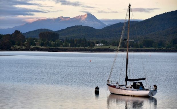
 Reflections on Lake Pukaki

 Once arid land with irrigation now runs thousands of cows just south of Twizel
 Ahuriri River running from the Lewis Pass past Omarama

 The Clay Cliffs, created out of layers of silt and gravel deposited by glaciers some 20 million years ago
 Ahuriri River
 Lupins used to be prolific in the area, especially along the roadside, but recently have been sprayed and are now mainly found in the riverbeds.
 The Avimore power station on the Waitaki River. Completed in 1968, it provides 30% of the nations power.
 Waitaki dam power house. Finished in 1934 it was the first hydro dam in NZ
Waitaki Substation distributes the 105MW of power produced here.
 St Albans church, just down river from Kurow
 Lush Pastures created with irrigation from the Waitaki river
 Drawings in the limestone caves near Duntroom

 Arriving in Oamaru at the end of a weekend festival.
 Steve’s friends, Michael and Lee-Ann, run the craftworks brewery in the old town part of Oamaru. This hand-made beer has to be aged in barrels for at least 6 months before drinking.
 A local friend of ours, Jodi, came to help us sample the beer.
 Around the corner we dined at the Criterion hotel, where the locals were still dressed in their period costumes.
 Monday morning around 9am – the town is very quiet on this dull day, the streets dominated by the marvellous Oamaru stone buildings.


 At the local cafe we ran in to Pam from New Plymouth, who is nearing the end of her bike ride from the top to the bottom of NZ
 The old Teschemakers Girl’s School near Kakanui, just south of Oamaru
 Kakanui Beach
 This church at Maheno was built by Colonel Nicholes in the mid 1930s to honour the soldiers who served in the first world war. This place is also where I started school a few years ago!


 The Maheno War Memorial, next to the church.
 Kuriheka Station Memorial with the large woodshed in the background.
 The house we lived in when my father worked here as a shepherd and where my mother cooked for the shearers and musterers

 This station is famous for all its Oamaru stone buildings. In the foreground are the stables, with the large homestead In the trees behind. It had its own hydro-station and sawmill when we lived there in the 50’s. It was once open to the public but alas no longer.


 Moeraki Boulders, which appear from the banks above the beach eventually getting ground away by the sea and turning into sand.
 We enjoyed a great meal of Blue Cod and chips at Moeraki’s Fishwife cafe, recommended to us by Peter and Julie, who we had popped in to see at Kakanui.

 Views from the Fishwife Cafe

 Arriving in the Catlins
 Suart beach
 A very pregnant sealion waddled up the sand at Suart beach, heading for the scrub go give birth to her pups.
 The Catlins coast with it rugged cliffs and sandy beaches


 The Purakaunui Falls, easy to access through beautiful bush, are one of the most photographed falls in NZ
 Maclennan. River valley


 Thirty odd years ago a man parked his house bus here at Patatowai and spent his days making gadgets and developing an amusement park.
 Tautuka Bay – we drove the length this magnificent beach.

 Large Eucalyptus forests have been planted throughout Southland and are mainly harvested for wood chip.

 Curio Bay when the tide is out shows off fossilised logs which were laid down here in the ash of a large volcanic eruption 170 million years ago while NZ was still part of Gondwana. Since then NZ went under the sea and rose up again. Hectors Dolphins can also be seen in the next bay called Porpoise Bay .


 Waipapa Point Lighthouse is another interesting stop. This is a copper skinned building with the gap between the skins partially filled with rocks to stop it blowing away. Built in 1884 ,with a keeper’s cottage nearby, it still operates electronically with the keep having being retired years ago.
 Tiwai Point, a large aluminium smelter which consumes over 10% of the country’s power. Located on a peninsular just north east of Bluff and built in 1974 on the promise of cheap power from the Manapouri dam it is still hanging in there, with constant threats from the owners to close it.
 Bluff Port


 Looking north from the hill above Bluff. Just southwest of here, a short boat ride away is Stewart Island, a place I have yet to visit.


 Invercargill is NZ’s most southern city with a must-see, privately owned transport museum. Bill Richardson collected cars and trucks most of his life and when he died in 2004 he had amassed 170 vehicles, His family continued the collecting and there are now some 300 cars, trucks, tractors and more in the museum.
 Further down Tay Street there is a large motorbike collection, recently purchased by the Richardson family to prevent it leaving NZ
 In the local hardware store you will also find the “World’s Fastest Indian”
 This is the Indian motorbike that Burt Munro made history in by reaching 105.67 MPH across the Bonneville salt flats in 1967.
 The picturesque little town of Riverton.
 Sheep farming is the main income stream in this part of NZ.
 Otahu School that operated from 1913 to 1956
 This weir controls the water level of both Lake Manapouri and Lake Te Anau, which link up here, supplying water to the Manapouri underground power station that supplies the power to Tiwai point.

 Dawn breaks at Lake Te Anau
 Heading north for Milford Sound on highway 94

 Eglinton river flats

 The Mirror lakes hosting NZ’s smallest duck the scaup
 The Hollyford valley

 With a high rainfall, large rocks are used to protect the roads around here; every year there are road closures from slips, washouts and avalanches.


 The Homer tunnel with its traffic lights to control the one way traffic. its a big job just clearing the avalanches above here in winter.

 Mitre Peak at Milford Sound
 A large carpark able to cater for 28 large tour buses hosts only one half bus. Now is the time for all Kiwis to get down here and look at this stunning part of the world.
 There are 15 tour boats based here. Just now only 3 or 4 are operating a reduced schedule. Many of the aircraft are either tied up on the ground or have been moved elsewhere for storage.


 Bowen Falls, the water supply for the generator, is fed from the top of this spectacular waterfall. There is now cellphone coverage in this part of the world.

 Trees grow in these cliffs by intertwining their routs to hang on, every now and again one near the top lets go taking all those below with it. They take about 150 years to grow again.
 These cliffs plunge vertically straight down into the water, in some places to 500m below the water level.


 The fjord is some 12 miles (19k) long and up 2 miles (3k) wide. It is actually a fjord as it was created by a glacier a few million years ago. It was the NZ Navy who mistakingly called it a sound early last century.
 Fur seals are a common sight here.

 These Fiordland Crested Penguins (an endangered species) return here from the Antarctic each year to breed.


 As we leave here we have a good understanding as to why Rudyard Kipling named this place the Eighth Wonder of the world.


 As it is the only road in we had to head back to Te Anau before following highway 94 through the stunning farmland of Lowther, Athol, Garston and Kingston to Queenstown.
 The entrance to the town of Cromwell, known for its fruit and cherry growing.


 Lake Dustan the last of NZ’s hydro dam lakes, settled in a valley between the Pisa range and the Dunstan range, is now a grape growing area.


 The Lewis Pass on Highway 8 reveals some more spectacular hills

 The mighty Rakaia River on the east side of the Southern Alps.
 Large trees grace the old town of Hamner.


 The Waiau River running from the Lewis Pass

 Marau Springs Hotel on the west side of Lewis Pass
 The hops farms of Motueka

 Harwoods Hole, 176 meters deep, runs into an underground river, which one can walk out after abseiling down into the hole.

 Atop an interesting rock formation near the hole is a great view out to Takaka.


 Arriving back at the car from the hole we discovered a group of Kea (a native parrot) ripping apart an inner tube some one had as a bike tie on the back of their car. They are quite cheeky and have been known to tear the rubber from around car windscreens.


 The area around Takaka revealed some stunning beaches as well as Steve’s corner.

 The Takaka hill road exposed some great views back towards Kaiteriteri.

 Sandy Bay Just north of Kaiteriteri.


 Kaiteriteri
 Split Apple Rock
 Havelock, at the head of Pelorus Sound
 Pelorus Sound
 The port town of Picton where the ferry departs for the North Island
 A spitfire, one of the many planes displayed at the aviation museum near the Blenheim Airport. This is well worth a visit.
Roger James: What a super surprise to discover this piece online. I truly have an appreciation for your talented photography and especially your gifted ability to convey so much of the elements of your journey in your writing!
I have never had the pleasure of making my own journey to explore N.Z. and to re-connect with several wonderful friends, whom I had met many years ago, when I resided in N.Y., London, and Virginia. One family still resides in Christchurch and another chap lived in Aukland. Your journals have inspired me to reconnect with distant friends and continue to keep New Zealand on my Bucket List! I thank you! And, I wish you Happy Trails…
Some top tips and great photos… cannot believe you have not been to Stewart Island! Awesome place, but I have not visited since 1995, so I’ll come!
Fabulous photos Roger. Worthy of a coffee table picture book.
Looks like an amazing trip around the South Island. Thank you for sharing.
fabulous pics…reminder of our trips over the years with our girls…we sure covered a lot of distance, they were very well traveled young children! The scenery is spectacular …the best part of NZ for sure….and lovely to see you at Lower Hutt, what a coincidence!!
Absolutely stunning photos.
Love all the scenery! Can’t beat the south island!
The little church (stained glass!!) and some of the quilt cafes (especially fish wife) were very Interesting photos.
Cheers
Fascinating photos, as ever! Murray has shown some of them to some Kiwis
from the tennis club, asking how much do they really know about their home
country?
I loved seeing the lovely farmhouse where Dilys and Alun lived after they arrived in NZ! Lovely looking home.