Sunday 18 June 2017
I spent Saturday in Singapore with Renee and Cale, who are at present non-stop traveling around Asia. This included a stroll down Orchard Road and a visit back to the Battle Box at Fort Canning Park. The second tour I enjoyed as much as the first.
Midnight Sylvia and I boarded a plan for our flight to Marseilles via Frankfurt. We picked up a rental car – the worst car I have driven for many years. It probably rates close to the Ford teams van I had in the seventies; even on a straight piece of smooth road it wanders, requiring constant correction. Every corner it feels like it wants to tip over. Now aptly named the Citron Tipper.

We headed out to Avignon.


Dating back to 100 AD it has a history full of attacks and plagues etc. like most cities in this part of the world. In the mid 1300’s a 4300m wall 8m high was built around this city. During the 13 hundreds a number of popes hung out here. It was their funds that were used to build the wall and the many large buildings behind it. Today 12,000 of the city’s 90,000 population live behind the wall.
Arriving in Montpellier just after noon, we wandered the streets finding a lovely outdoor cafe and enjoying some local food. This town, with its old buildings and fantastic way of blending the old and the new, has a relaxing vibe about it. The history here is impressive but I wrote about that last year.


Monday 19 June 2017
After dropping Sylvia off at the Royal Canin head office, I drove the tipper carefully through the country lanes and up the hill to Gallargues-le-Montueux.

Overlooking the surrounding countryside, with its narrow crooked streets and a population of 3,500, it’s a really neat quiet town.


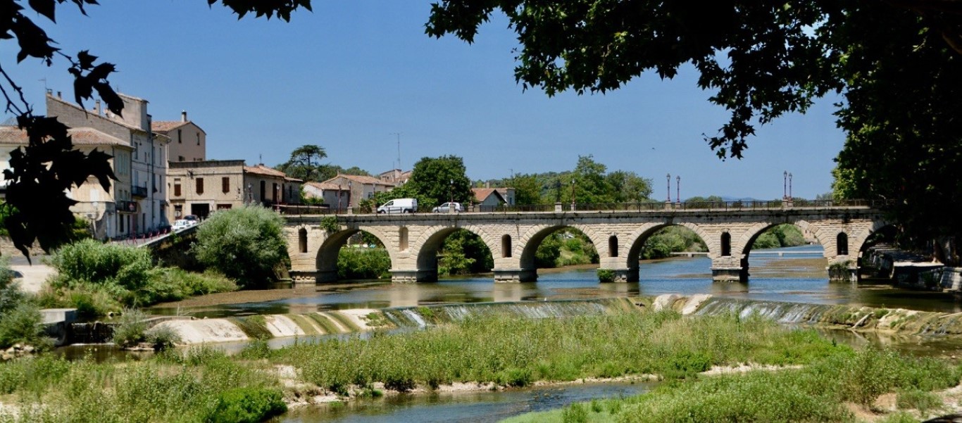
A short drive through some scrubby and scruffy countryside landed me at Sommieres. This place has been around a fair while. In the first century AD Tiberius, a Roman emperor, had the bridge built; not quite as wide as it should have been as I had to drive the Tipper up onto the footpath to let an on coming truck pass.
In the eleventh century a chateau was built on the hill. Later fortified and strengthened, it became part of the French kingdom in 1248. Later it became known for a siege in 1573 when held by protestants. They held off the other side for a couple of months by pouring boiling oil and molten iron on the attackers. There were a couple more sieges the following centuries as the two religions fought it out.


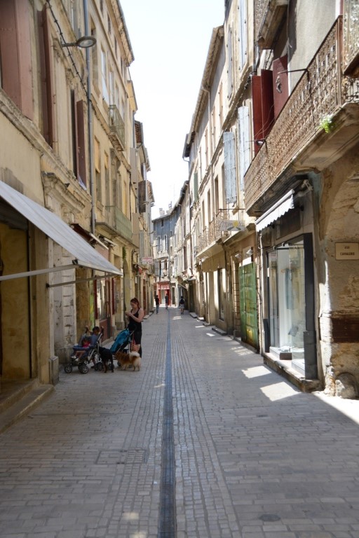
I parked across the river and strolled across the bridge to the main town. At the end of the bridge one of the original city gates leads into the cobbled streets. It was while wandering the streets I realised what it is that draws me to these places. Every street and every building is a little different. Nothing seems to follow a straight line – it’s almost like they always laid the footings of the buildings in the afternoon after a long wine lunch. Walls often bulge out, arches are often present. One wonders if they are there to hold the buildings apart. In the back streets lies an abandoned church.


The road winds its way up to the Chateau which looks to be in good order with its tall tower but is closed just now. I followed a track in the bush running up the ridge alongside the now crumbling fortress walls. The view from up here was stunning.


The track eventually leads me back down the hill where I come across a stone tunnel. I can see vehicle lights well in the tunnel. There were no rail lines and the lights seemed to be moving away from me so I ventured in. A few hundred meters later I reached the other end of this handmade, old railway tunnel, now being turned into a cycle way.


After the tunnel a deep cutting continued for a while and eventually the ground flattened out and I was able to sneak through a hedge onto the road that lead back to town.
After a relaxed lunch I drove around the district coming across many small villages. Most had a chateau, church or fort, and sometimes all three, on the high ground.


Wednesday 21 March 2017
From the chateau at Sommieres I had spotted a nicely shaped hill in the distance. I showed the picture to the guy on the desk at the our hotel. Pic Saint-Loup he said. I asked if one could take a stroll to the top. “It’s very hard and takes four hours, you have to go very early in the morning.”
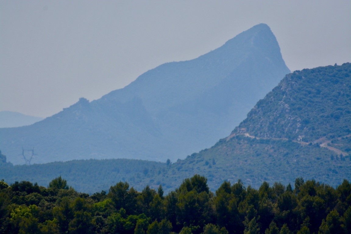
After dropping Sylvia at work I drove to the general area of the hill. Eventually I found a car park and a track. Forty minutes later I was at the top. At only 662m, with the car park at 300m it wasn’t exactly a big climb. The hill itself is impressive. On the north side it has vertical bluffs and is the highest hill in the area with great views of the surrounding countryside. There is also a stone church and a cross at the top.


A thirty-minute stroll down the hill on the rough track, often shaded by the surrounding scrub, and I was back at the car.

Around 6pm I picked Sylvia up from work and we headed to Aigues-Mortes.

Rumour has it Gaius Marius founded this city in 102 BC. With its nearby salt flats this became quite a sought after area. In 1272 the order was given to build a wall to encircle the small town. It took thirty years to complete. These are the most impressive city walls I have seen in this part of the world. At the east end of the town is a tall tower originally used as a watch tower to warn of approaching bad people.

Behind the walls is a thriving little town with lots of restaurants, shops and housing.


Thursday 22 June 2017
I headed to Saint-Mathieu-de-Triviers, a town to the west of Pic Saint-Loop. I was amused driving through the town’s narrow streets to see signs indicating the street width. Down one of these streets I came across two opposing houses with big scrape marks down their sides. Someone didn’t read the sign.

Soon I found the track heading up the hill starting at 130m and 7 kms from the top. As I scrambled up some loose rock I looked up to see the remains of a Chateau well above me.

As it turned out, the track lead right up to the centre of it. With vertical cliffs on the north side and four tiers of 4-meter high walls to the south it must have been quite a fort in its day. It first appears in history in the mid 1200’s. It survived a major siege and a few other battles. When in 1659 Jacques Valant the then owner died it began to decay. In the 1700’s Louis XIV authorised a local bishop to destroy the buildings. The stones were offered as compensation for those carrying out the demolition. By then people must have got sick of carrying stones as the task was never completed. Today it’s pretty derelict but must have once been a great feat of engineering. One can still see partial remains of tunnels, caverns and the outline of the main buildings.


Climbing down the east end I found the main track with a sign on it. I assume it said something along the lines of “Chateau ruins, come and take a look around.” I am sure my French speaking friends will enlighten me if I got it wrong!

The track continued along the side of the hill with the odd branch of to the ridge. Eventually the track joined with the track I had come up yesterday for the push to the summit. At the summit the weather was still hazy and not good for photography so I rested a few minutes and then returned the way I had come.

In the evening we took a trip to Nimes. The old city here has a Colosseum built by the Romans in the first century. As we arrived people were preparing to enter for a musical event. All the roads around the area were blocked off with trucks and armed police, we presumed to stop vehicles getting near the crowd. The old city here is less attractive than the others we have seen so far.


Thanks, Roger. What a book seller this would be for budding travelers
Take care