Glentanner Station, Mt Cook, New Zealand
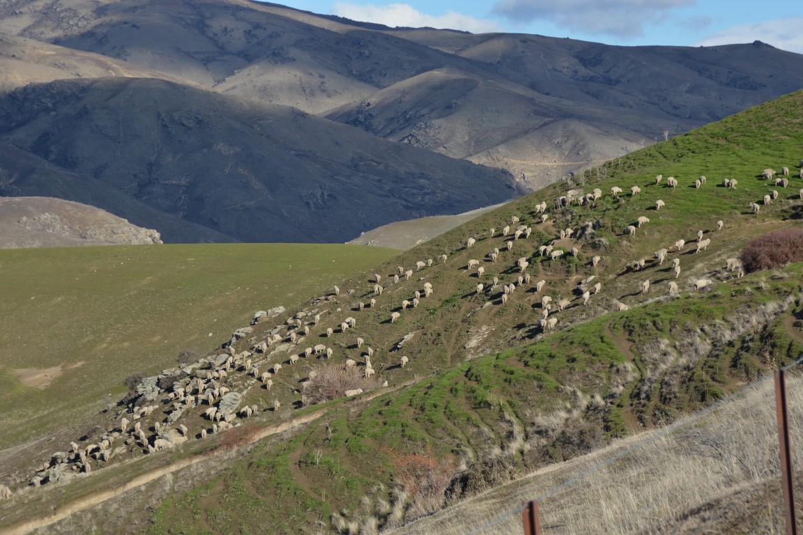
Every year I have the privilege of spending a few weeks down south at Glentanner Station. Owned by Ross and Helen, the station runs around ten thousand merino sheep and a few steers. It also encompasses Glentanner Park, a tourist centre with accommodation, and the Helicopter Line flights into the surrounding mountains.
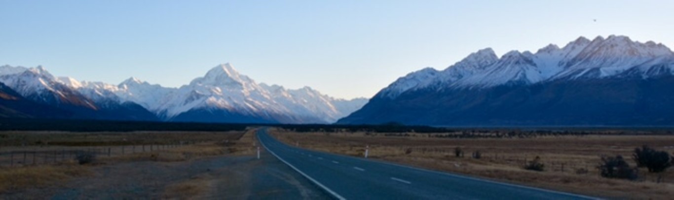
Driving up the side of Lake Pukaki on Monday evening I was, as always, taken aback by the scenery, in my opinion the best in the world. The blue-green colour in the lake running east into the golden tussock to the north, and to the west the snow capped mountains of the southern alps.


It’s always great to catch up with Ross and Helen – we chatted away the evening over a glass or two of nice red wine. I am here to help reduce the prolific rabbit population and at the same time hone in some long range shooting skills.
On Tuesday morning I set up some targets with the 7000ft Mt Mary rising up behind the targets. Rifle zeroed, I was then able to put the Kestrel Ballistics programme to use. The rifle is zeroed at 100 yds. After the bullet passes that point the programme calculates the bullet drop, which is around 15 inches at 300 yards and 36 inches at 400 yards. To hit rabbits at ranges from two to four hundred yards the calculations have to be very precise. With the aid of a pair of good binoculars, complete with a range finder and a good telescopic site on the rifle, ( was able to engage rabbits effectively out to 380 yards in the surrounding paddocks.

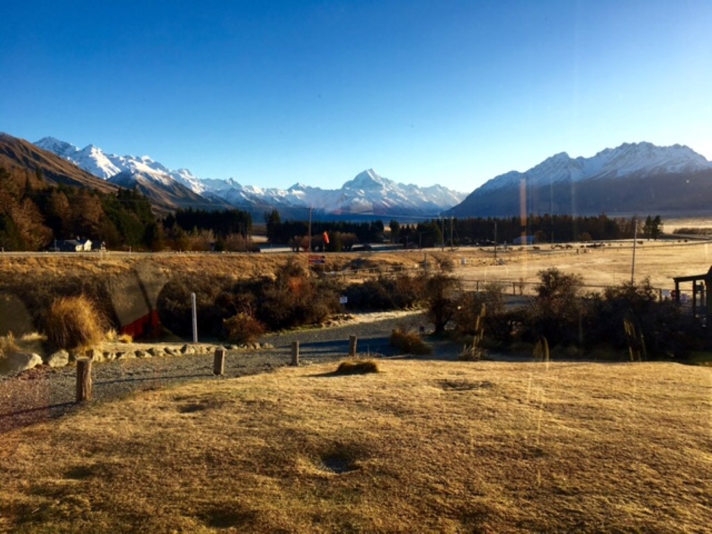
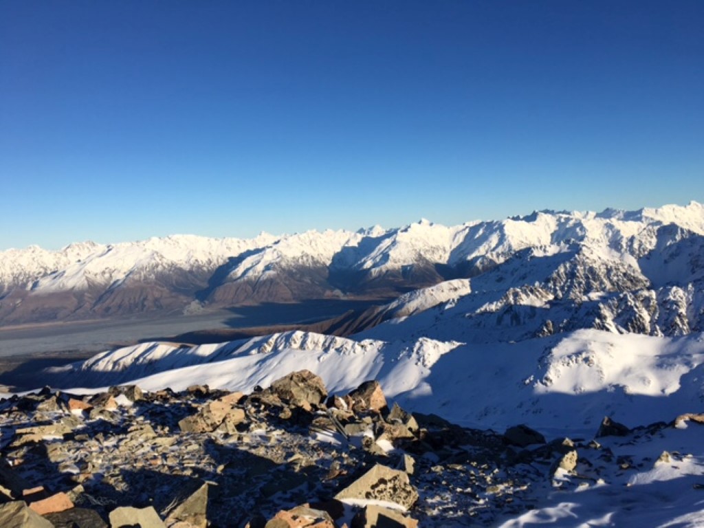
The next morning Richard, one of the Helicopter Line pilots invited me along to give a hand putting up some solar panels. We flew to Tekapo Military camp where we picked up the three technicians and their equipment. We then flew up onto Mt Stevens. At just under 8000ft it was a little chilly with stunning views out over the McKenzie Country with its bright blue lakes and golden brown tundra. To the west and north are snow capped mountains including Mt Cook at 12349ft NZ’s highest mountain.


After dropping us off he went and picked up the steel frame returning with it slung under the helo. After dropping off the load the helo was parked on the ridge just below us. Richard was giving us a hand when one of the guys looked up to see the rotor blades staring to turn on the helo (not a good sign). Richard raced down with one of the guys and tied the blades down. The wind was picking up and white clouds rolling in over the Alps. We had to abandon the job. The guys went back and finished it the next day.


Later in the day I gave Ross a hand to shear four big old merino rams. I dragged them out of the pen and Ross did the shearing. At ten years old they had reached their use by date. The next evening we butchered two each so the meat could be fed to the dogs.


There is always lots to do at Glentanner. They feed out hay everyday here during the winter and every second day down at the other farm at the bottom of Lake Pukaki, a 40k drive from here. Over the next few days I get to load up and deliver firewood to the camp ground, help Ross cut down some trees and replace a couple of broken skylights on the woolshed.
I head down to the other farm with Ross and go looking for rabbits while he feeds out. Ross’s son Mark, his wife Kate and theriethree children are building a new house at the bottom farm. With stunning north-facing views up Lake Pukaki to Mt Cook, the Alps to the west, and over the flats with Lake Benmore in the distance to the south. The new house, with solar panels, batteries and a generator, will not be connected to the electricity grid.
On Saturday Ross and I drove the three hours to Christchurch checking out a gun show in the afternoon. In the evening we met Ross’s son George and his mates for his stag party. I will have to leave the night’s activity to your imagination.
Another day the hay feeder at the bottom farm broke down so I took the Glentanner one down so Mark could finish feeding out. I delivered the broken one to the engineers in Twizel for repairs.
Helen, after a busy day running the park or tending to the lovely gardens surrounding the homestead, always prepares a great dinner. We spend the evenings in front of the fire chatting and enjoying a glass or three of red wine.
Suddenly twelve days have passed, 248 rabbits have died (a tiny dint in the population here) and it’s time to leave.
A Glimpse of the West Coast
Driving south through Omarama and over the Lindis Pass to Queenstown, I did something I had been meaning to do for years. I stopped many times and took photos of the stunning scenery. Driving down from the Pass alongside the Lindis River the land opens out into a large valley then flats leading through Tarras to lake Dunstan. This has been sheep country for over nearly a hundred and fifty years. A café at Tarras has a picture of wool being carted out on bullock trains. The lower flat land near the lake is now irrigated and running dairy cows. The beauty of this land is further enhanced by the way the scenery changes so quickly.


Passing down the east side then across Lake Dunstan at Cromwell, it’s then into the rugged Kawarau River canyon. Cromwell, once famous for its cherries and other stone fruit now has added grapes to its repertoire. As the Kawarau Gorge opens out at the Queenstown end, the once barren land is now covered with grape vines producing some of the world’s finest pinot noir.


At the Queenstown airport I picked up my good friend Steve for our road trip up the west coast and back to Auckland. We spent the night in Queenstown catching up over a nice meal.
Saturday morning we headed for Wanaka over the Crown Range only to be turned back as we did not have chains. Detouring through Cromwell we stopped at Hawea where the road to the west coast begins. The guy at the petrol station told us the road may open soon. We pushed west along the south side of lake Hawea. As we got to the west end of the lake we spotted a pickup stuck in the mud near the lake edge.


The land enhanced by the rain and sleet dominates the scene with its hard rugged beauty. Soon we are heading up the northwest end of lake Wanaka which runs up into the Makarora river. We stop in at a rugged roadside café. The grumpy proprietor tells us the pass is closed but should open soon. We order breakfast and sit by the log fire. We discuss with amusement a couple of the café signs: “Shoplifters will be shot” and “if you think you can do it better buy the place”.
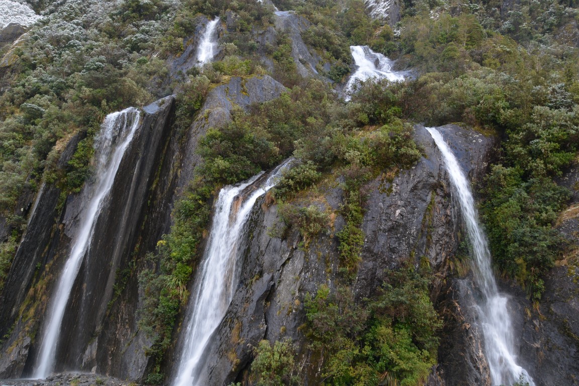
After an hour or so the Haast Pass opens and we continue west, driving through the snow covered bush rising up to cliffs with waterfalls thundering down, sometimes hundreds of meters. Over the Pass the road runs alongside the Haast river; with its blue green water and large boulders it has a rugged power about it.


Reaching the West Coast and the town of Haast we head south to Jackson’s bay. Snow lies on the roadside at sea level. A large slip almost blocks our way. A boat sits up among some houses. Very small fishing boats are moored close to the wharf. This is as far south as the coast road goes.


Back up the road a little we find a shingle road and follow it southeast. In good condition, this shingle road has been upgraded so tourists can drive through some beautiful bush alongside the Jackson River. The road heads over a range and down into the cascade, with vast views out over plains to the sea. This is cattle country and has been for some hundred years plus. At the bottom of the hill there is a locked gate; it’s the end of the road for us tourist types.


We headed back up the coast to Franz Josef in time to visit the reflective Lake Matheson before dark.


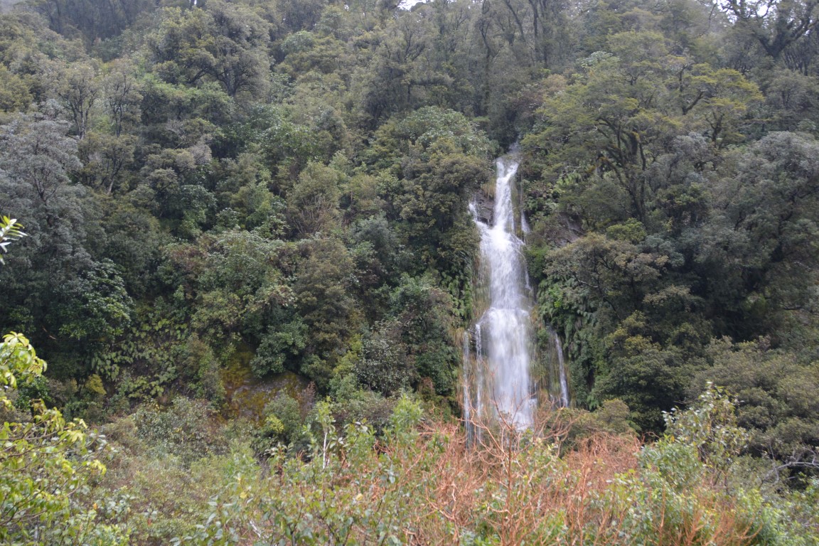
Sunday morning we head up the Franz Josef River to see the Glacier. Things gave changed around here since my last visit in 2003. DOC (Department Of Conservation) has built a nice car park and a wide smooth track up to the glacier. The only problem is the Glacier has buggered off up around the corner. The closest we can get is nearly a kilometre away. Last time I was here one could stand by the ice river and look up at the glacier. Lots more snow is needed up high to push it back down the valley again. In spite of that the scenery is stunning with cliffs, mountains and waterfalls to gaze up at.


We head north stopping at some of the small towns along the way. Once heavily forested, large areas now graze dairy cows. We check out the rugged beach and town of Hokitika and the wharf areas on the rivers at Greymouth and Westport.


The prevailing southwesterly wind is pretty obvious from the shape of the trees along the sea-shore, that look like they’ve had a styled cut at an Auckland salon as they bend over to the northeast.


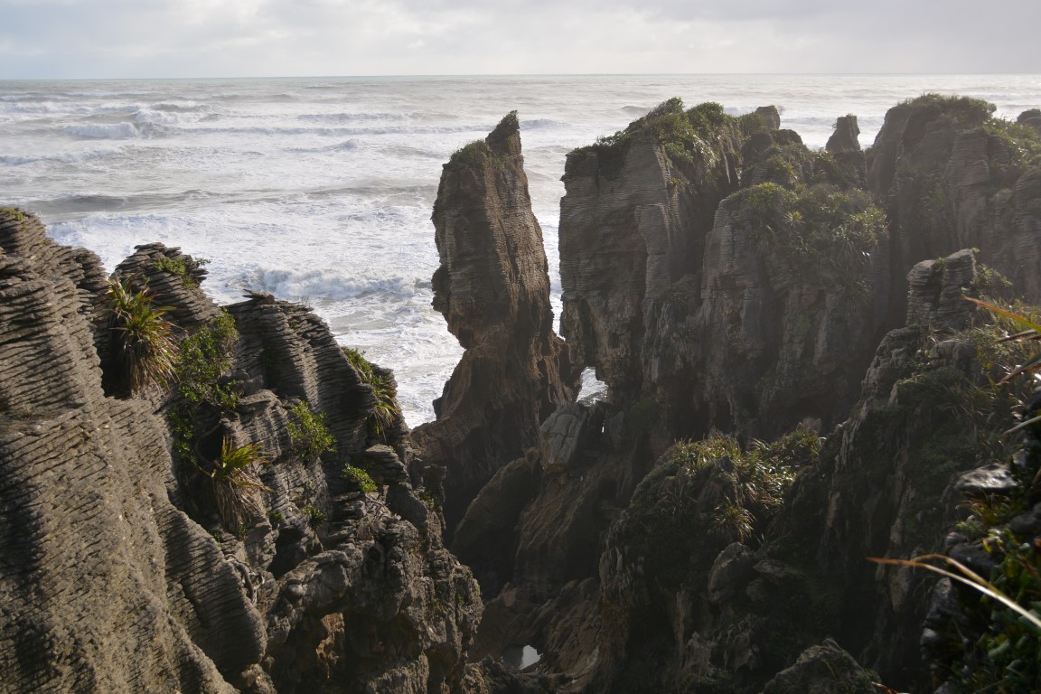
The Pancake Rocks (Punakaiki) was another stunning place where DOC have created a sealed path through the shrubbery to the coast.


North of Westport is the Dennison Incline. This place has intrigued me for many years. Opened in 1879 with a mine behind the main buildings from which a chain of 12 ton coal wagons were lowered down the incline at a rate of 14 per hour on cables with water filled pistons used as brakes. Fresh water had to be injected into these on each stroke as the friction was so great that the water would boil. The incline dropped 510m over 1.7 klm. Near the beginning it looks in excess of 45 degrees. The mine behind was eventually turned into a tunnel to access coal seams further back. The incline was closed in 1967 having transported some 12 million tons of coal. The only way up to the site until the 1950’s was to walk or ride a returning wagon.


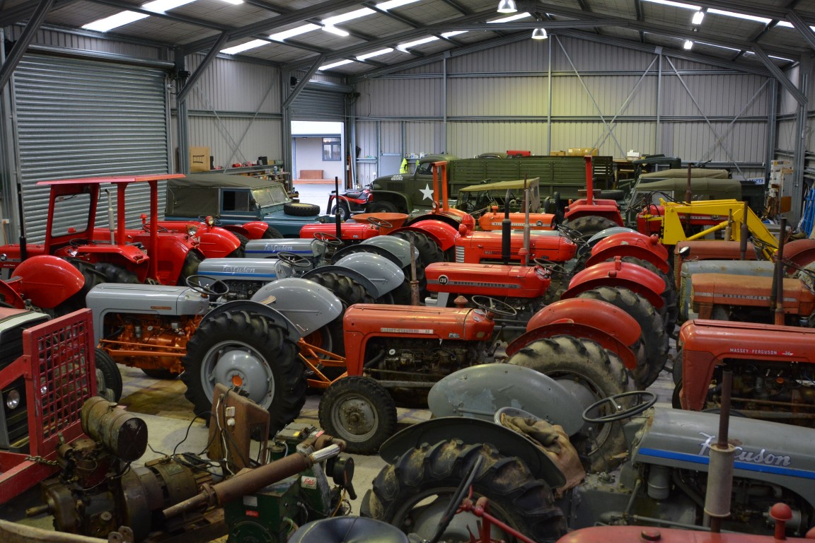
It was nearly dark when we headed north up the coast. Arriving about eight at Little Wanganui we headed into the pub. A line of red band gumboots stood on the door step. I felt quite at home as I lined mine up beside them. After booking a room we were soon leaning on the bar chatting to publican Wayne. We enjoyed a great meal of big bangers and mash. One of the locals came over and joined us; Tony was soon joined by Jeremy, an adventurous young farmer’s son who was well traveled. Apparently they had had a bit do here last night – Jeremy had left his car here and arrived on his tractor tonight so didn’t stay too late. Tony wandered of too, saying before we left that we should pop in and see his tractor collection in the morning.

As we left in the morning Jeremy’s tractor was still parked outside the pub. They get so much rain around here they refer to the vast native forests as rain forest. We headed into Tony’s. Behind his new house were two big sheds. Tony had sold his farm recently and taken up collecting Massey Ferguson tractors and a lot of other vehicles. Everything was immaculate, the shed clean, tidy and well laid out.


We checked out the river mouth, once a thriving port. After the 1929 earthquake this part of the country was cut off by road for two years. Back to Westport then up through Murchison along the Buller River. In places here the road is chiseled into overhanging rock.


We stopped at NZ’s longest swing bridge, an old gold mining area. Here you can stand next to a fault line and see where the ground on one side of the fault rose up over four meters during an earthquake. The river at times rises with signs showing it rising up to 20 meters during floods.


We stopped in Nelson to see an old friend and mentor of mine. Rusty was the Regimental Sergeant Major of an army unit I belonged to as a young soldier. He is a man of great wisdom and foresight whom I learnt a lot from and have been lucky enough to stay in touch with.
Last light was upon us as we rounded the last part of Queen Charlotte Sound into Picton.
As we departed Picton the next morning on the ferry for Wellington we spent time reflecting on the the stunning sights and great time we had both had rediscovering the West Coast of the South Island.


Looks like a wonderful trip Roger.